Natural Disasters Affecting Shandong Province
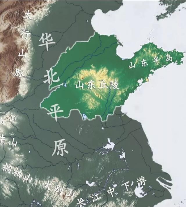
Shandong Province, also known as Qi and Lu, is located in the eastern coastal region of China, bordering the Yellow Sea to the east, the Bohai Sea to the north, and bordering Hebei, Henan, Anhui, and Jiangsu provinces on land. The province's capital is Jinan, often referred to as ‘Lu’. It stretches 721 kilometers east to west and 437 kilometers north to south, with an area of 15.58 square kilometers and a population of 100.06 million. In 2019, its GDP production value reached 71067.5 billion yuan, making it the strongest economy province in the north and ranking third nationwide. Major cities include Jinan, Qingdao, Yantai, Weifang, Dezhou, Rizhao, etc. Famous attractions include Mount Tai, Liu Gong Island, Confucius Temple, Weishan Lake, Laoshan, Nanshan Scenic Area, Baotu Spring, Penglai Pavilion, Tai'an, among others. Mount Tai is the highest peak in Shandong, with an average altitude of 1532.7 meters. It belongs to a temperate monsoon climate, with an average annual precipitation of 500-1000mm and an average annual temperature of 11-14℃. Precipitation is concentrated in the summer, with a rainy season and a hot season, with short springs and summers, and distinct seasons.
Shandong Province, the ancient lands of Qi and Lu, is a land of great people and auspicious land with excellent geomancy, a contested territory for armies. However, Shandong Province’s geographical location is unique, being located on the edge of the seabed, prone to frequent natural disasters. What natural disasters might Shandong Province be susceptible to?
First, earthquakes
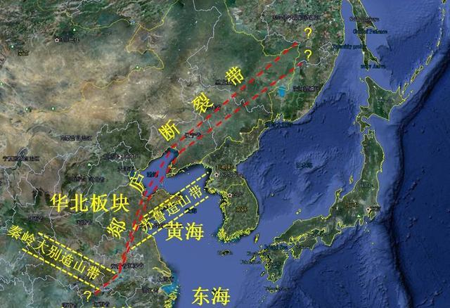
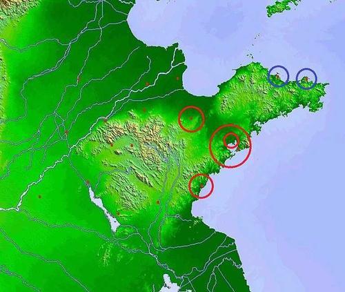
Shandong Province is located above the Pacific Ring of Fire and the boundary between the Eurasian and Pacific Plates. Shandong’s earthquake-prone areas are mainly in LinYi and TangCheng, specifically the renowned TanLu Fault Zone, accurately called the TanLu Fault. However, apart from the large earthquake three hundred years ago, Shandong Province has been peaceful in recent years. Mount Tai and Mount CuLei, two mountain ranges, have a vast underground crack valley between them, reaching hundreds of meters deep, which increases the possibility of earthquakes in Shandong Province.
Second, typhoons, floods, and heavy rain
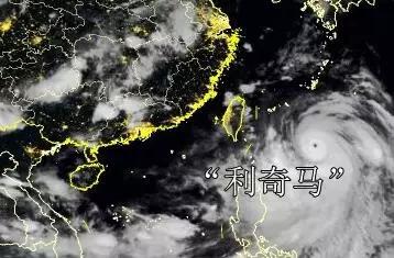
In 2019, Typhoon ‘Liqueche’ landed in Zhejiang on August 10th, then moved north towards Shandong Province along the coast, subsequently landing twice in Qingdao and Huangdao District, with maximum sustained winds near the center of 9-23 meters per second. It severely impacted Shandong Province, eventually weakening and moving towards Japan. ‘Liqueche’ typhoon brought heavy rain to Shandong and other places, with an average precipitation of 180mm, with Wangxincun town in Qufu reaching a maximum of 713mm, with heavy floods in the central and southern parts of Shandong and the northwest part of Shandong. 165.53 were affected by the typhoon, with 5 deaths and 7 missing, and 175.4 thousand hectares of crops were affected, resulting in direct economic losses of 14.75 billion yuan. However, Shandong Province has rarely been affected by typhoons, but the combined influence of typhoons, heavy rain, and flooding is rare.
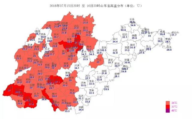
Third, heat, drought, and other natural disasters
The influence of the ‘El Niño phenomenon’ extends to the south of China, pushing the subtropical high pressure belt outwards, resulting in extreme weather in Shandong Province, such as high temperatures and droughts in mountainous areas. Shandong Province belongs to a temperate monsoon climate with an average annual precipitation of 500-1000mm and an average annual temperature of 11-14℃. In 2019, affected by the ‘El Niño phenomenon’, rainfall in mountainous areas was 50% less than in previous years, reaching the lowest level since 1951, with continuous drought and river and lake drying up in Weihai and Yantai, Weihai City activated the third level of drought emergency response. Simultaneously, multi-day high temperatures occurred, with eight cities including Dezhou, Binzhou, Hefei, Jinan, and Weifang experiencing temperatures above 35℃, with localized areas reaching 37℃ above. According to data, in 2019, Shandong Province’s average temperature was 14.6℃, 1.2℃ higher than the average, which was the highest since 1951, with Weishan and Jinan exceeding historical extremes.
Fourth, other natural disasters
The province is susceptible to frequent natural disasters in spring and winter, such as large-scale fog and haze; in some years, in the spring and summer, it is affected by strong winds and hail; occasionally, there are tornado disasters; and there is a significant possibility of mudslides.
Pure personal view, original work, thank you for reading.